InfoPlot - plot boundaries 2.1.36
Free Version
Publisher Description


InfoPlot - plot boundaries - Find the boundaries of every plot in Poland.
YOU WILL FIND THE BORDERS OF EVERY Plot IN POLAND!
The application is a tool that integrates public data on cadastral plots in Poland in one application.
InfoDziłka uses the services of the Central Office of Geodesy and Cartography and other GIS data provided by various institutions and companies. The application was awarded by the Surveyor General of the Country in 2020.
The application is intended for users interested in comprehensive information about every plot in Poland.
The most important function of the application is to find plots and their boundaries in the field using a mobile device, including precise subcentimeter industrial GNSS/RTK tablets.
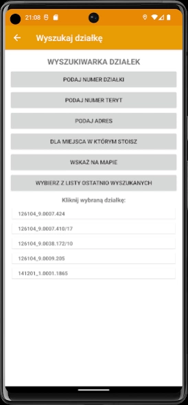
THE APPLICATION PROVIDES THE FOLLOWING INFORMATION ABOUT EVERY Plot IN POLAND:
· information about the location of the plot: voivodeship, poviat, commune, town, precinct, district, plot number and TERYT number,
· XYH coordinates of the boundary points in the selected coordinate system,
· plot dimensions,
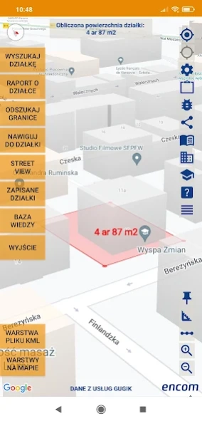
· plot area,
· maximum plot slope,
· information about the plot's purpose in (MPZP) with a link to full data from the MPZP²,
· information from the Study of Spatial Development Directions²,
· information about the underground utilities of the area (GESUT) ²
· land use information (BDOT) ²
· information from the Register of Land and Buildings (EGIB)
· map of the plot against the background of satellite and topographic maps
· map of the plot against the background of the GUGIK Digital Terrain Model
· plot map in a KML file
· map of the plot and height pickets in a DXF file,
· orthophotomap with a pixel of approximately 10 cm ²,
· standard orthophotomap
· information about building permits
· information about areas at risk of flooding
'SAVED PLOTS' FUNCTION:
This function is intended for registering downloaded information about plots directly in the device.
The function allows:
1. Manage saved plot information.
1.1 Registration of information about the plot (report, descriptive data of the location, list of coordinates of boundary points, calculated area).
1.2 Supplementing information about the plot with any number of photos. Photos taken in the InfoDziałka application additionally save information about the location of the photo and information about the plot in the metadata of the JPG file (EXIF). The user can present the location of the photo in InfoDziałce or another tool.
1.3 Supplementing information about the plot with data obtained by the user about the owner/seller of the plot
2. Export or import selected plots to Google Drive or email etc.
3. Aggregation of information about selected plots into an Excel file.
4. Export selected plots from the list to a DXF or KML file.
5. Presentation of many selected plots on a map.
'NAVIGATION TO THE PLOT' FUNCTION:
An application function that starts navigation on your smartphone after selecting a plot.
'FINDING BOUNDARIES' FUNCTION:
Application function designed to find the boundary points of a selected plot. The application will indicate the direction and distance the user must walk to find the border point. Accuracy depends on the accuracy of the location determination by the smartphone.
'PLOT REPORT' FUNCTION:
Function presenting data about the selected plot. Descriptive data about the location (voivodeship, poviat, commune, district, plot number, TERYT number, registration area, registration group, use, contour marking, date of data publication by GUGIK, list of coordinates of border points and calculated plot area.
Project website: https://infodzialka.pl
² possible lack of data for some areas in Poland
About InfoPlot - plot boundaries
InfoPlot - plot boundaries is a free app for Android published in the Recreation list of apps, part of Home & Hobby.
The company that develops InfoPlot - plot boundaries is ENCOM sp. z o.o.. The latest version released by its developer is 2.1.36.
To install InfoPlot - plot boundaries on your Android device, just click the green Continue To App button above to start the installation process. The app is listed on our website since 2024-04-17 and was downloaded 1 times. We have already checked if the download link is safe, however for your own protection we recommend that you scan the downloaded app with your antivirus. Your antivirus may detect the InfoPlot - plot boundaries as malware as malware if the download link to pl.encom.parcel is broken.
How to install InfoPlot - plot boundaries on your Android device:
- Click on the Continue To App button on our website. This will redirect you to Google Play.
- Once the InfoPlot - plot boundaries is shown in the Google Play listing of your Android device, you can start its download and installation. Tap on the Install button located below the search bar and to the right of the app icon.
- A pop-up window with the permissions required by InfoPlot - plot boundaries will be shown. Click on Accept to continue the process.
- InfoPlot - plot boundaries will be downloaded onto your device, displaying a progress. Once the download completes, the installation will start and you'll get a notification after the installation is finished.
